
7 Great Flood Documentaries That Made Waves About 1993's Disaster
Exploring the Midwest Deluge's Impact

The Great Flood of 1993 stands as one of the most devastating natural disasters in U.S. history. This catastrophic event inundated the Mississippi River and its tributaries, causing widespread destruction across nine Midwestern states. Several compelling documentaries have captured the scope and impact of this slow-motion disaster, offering viewers a deeper understanding of its far-reaching consequences.
These films provide unique perspectives on the flood's causes, its immediate effects, and the long-term recovery efforts. Through interviews with survivors, historical footage, and expert analysis, they paint a vivid picture of a region grappling with unprecedented water levels and the resilience of communities in the face of nature's fury.
The documentaries exploring the Great Flood of 1993 serve as important historical records and educational tools. They remind audiences of the power of natural forces and the importance of preparedness in disaster-prone areas. By showcasing both the destructive potential of floods and the human capacity to rebuild, these films continue to resonate with viewers decades after the waters receded.
The Severity of the 1993 Great Flood
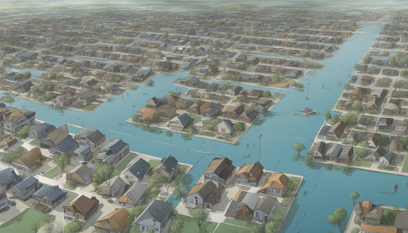
The 1993 Great Flood caused unprecedented devastation across the Midwest, breaking records and reshaping landscapes. Its impacts were felt far beyond the riverbanks, affecting millions of lives and acres of land.
Record River Levels and Rainfall
The flood shattered previous high-water marks along the Mississippi and Missouri Rivers. Many locations experienced crests 6 to 10 feet above flood stage in April and May. By June, water levels had briefly receded, only to rise again to catastrophic heights.
Rainfall totals were staggering. Some areas received three times their normal precipitation over the summer months. This relentless downpour saturated the soil and overwhelmed river systems across nine states.
The flood's duration was equally remarkable. At certain points along the rivers, floodwaters remained above flood stage for nearly 200 days. This prolonged inundation caused extensive damage to infrastructure and ecosystems.
Impact on Communities and Farmland
The Great Flood of 1993 affected over 20 million acres of land. Urban areas faced severe flooding, with numerous towns and cities battling rising waters for months. Thousands of homes and businesses were damaged or destroyed.
Rural areas bore the brunt of the disaster. Vast swaths of farmland were submerged, leading to crop losses and long-term soil damage. The flood's timing during the growing season exacerbated its agricultural impact.
Over 1,000 levees failed or were overtopped during the flood. This widespread breach of flood defenses left communities vulnerable and accelerated the spread of floodwaters across the region.
The human toll was significant. Fifty lives were lost due to the flooding. Thousands more faced displacement, economic hardship, and long-term recovery challenges.
Geographical Scope of the Disaster

The 1993 flood impacted a vast area of the central United States, inundating major river systems and affecting multiple states. Its unprecedented scale reshaped landscapes and communities across the Mississippi River Basin.
States Affected by the 1993 Flood
The flood's reach extended across nine states: Illinois, Iowa, Kansas, Minnesota, Missouri, Nebraska, North Dakota, South Dakota, and Wisconsin. Illinois faced severe flooding, particularly in its southwestern regions. St. Louis, straddling the Missouri-Illinois border, experienced significant inundation. The disaster forced thousands to evacuate their homes and caused billions in damages across these states.
Rivers and Basins Engulfed
The Mississippi River and its tributaries, including the Missouri River, swelled to historic levels. The Mississippi River Basin, covering over 1.15 million square miles, bore the brunt of the catastrophe. Major flooding occurred along the Upper Mississippi, Missouri, and Illinois Rivers.
The flood submerged vast stretches of farmland and numerous towns. In some areas, the Mississippi River expanded to over 3 miles wide, compared to its normal half-mile width. River gauge readings shattered previous records, with some locations remaining above flood stage for months.
Human Response to Rising Waters

The 1993 Mississippi River flood spurred massive mobilization efforts by communities and authorities. Residents and volunteers worked tirelessly to protect towns and crucial infrastructure as the waters rose to unprecedented levels.
Community Efforts and Volunteerism
Residents in flood-prone areas banded together to face the crisis. Volunteers from across the country flocked to affected regions, offering their time and energy. In Grafton, Illinois, locals and out-of-town helpers worked side-by-side, filling sandbags and reinforcing vulnerable areas. Churches and community centers became makeshift shelters and distribution hubs for supplies.
Neighbors helped neighbors evacuate homes and salvage possessions. Local businesses donated food and equipment to support relief efforts. The spirit of cooperation was evident as strangers united against a common threat.
The Role of Sandbags and Levees
Sandbags and levees formed the primary defense against the surging waters. Volunteers filled millions of sandbags, creating barriers to protect homes, businesses, and critical infrastructure. In some areas, sandbag walls stretched for miles.
Existing levees were bolstered with additional material to withstand the intense pressure. Engineers and workers labored around the clock to identify and reinforce weak points. Despite these efforts, numerous levee breaks occurred, inundating vast areas.
The flood highlighted both the importance and limitations of these protective measures. While sandbags and levees saved many communities, they also demonstrated the need for improved flood management strategies.
The Aftermath and Recovery

The Great Flood of 1993 left a trail of destruction across the Midwest, requiring extensive rebuilding efforts and imposing significant economic and environmental costs. Communities faced immense challenges in the recovery process, with some towns like Valmeyer, Illinois choosing to relocate entirely.
Rebuilding Communities
Many towns along the Mississippi and Missouri Rivers embarked on ambitious reconstruction projects. Grafton, Illinois, a small riverside community, saw nearly 70% of its buildings damaged or destroyed. The town's recovery involved elevating structures, reinforcing levees, and implementing stricter flood-resistant building codes.
Valmeyer made the bold decision to relocate its entire town to higher ground. This $35 million project moved the community 1.5 miles east and 400 feet up, creating a new town layout designed to withstand future flooding. The relocation took several years and required significant federal and state assistance.
Economic and Environmental Cost
The flood's economic impact was staggering, with damages estimated at $15 billion in 1993 dollars. Agricultural losses were particularly severe, with over 20 million acres of farmland inundated. Crop destruction led to increased food prices and financial strain for farmers.
Environmental consequences included:
Soil erosion
Water pollution from agricultural runoff
Damage to wildlife habitats
The disaster prompted changes in flood management policies. Federal and state agencies invested in improved levee systems, floodplain management, and early warning technologies. These efforts aimed to mitigate the impact of future flooding events and enhance community resilience.
Scientific Analysis and Predictive Measures
Scientific advancements have greatly improved our understanding of flood causes and prediction capabilities. These developments allow for more accurate warnings and better preparedness.
Understanding Flood Causes
Heavy rains and soil saturation play crucial roles in flood formation. Precipitation intensity, duration, and frequency contribute to flooding risks. Soil characteristics, including porosity and moisture content, affect water absorption rates.
The National Weather Service analyzes these factors to assess flood potential. They use sophisticated models that incorporate data on rainfall, soil conditions, and river levels.
Earth Observatory satellites provide valuable insights into large-scale weather patterns. This technology helps identify atmospheric conditions conducive to heavy rainfall events.
Advancements in Prediction and Warnings
Modern flood prediction relies on advanced computer models and real-time data collection. These tools allow forecasters to issue more accurate and timely warnings.
The Global Flood Atlas, a cutting-edge resource, maps flood-prone areas worldwide. It combines historical data with climate projections to identify vulnerable regions.
Weather radar systems now offer higher resolution and longer-range capabilities. This improvement enables meteorologists to track storm systems with greater precision.
Automated stream gauges provide continuous water level measurements. These devices transmit data in real-time, allowing for rapid response to rising water levels.
Documentaries and Media Coverage
The Great Flood of 1993 captured widespread attention through visual storytelling and comprehensive news coverage. Documentaries and media outlets played a crucial role in documenting the disaster's impact and preserving its memory for future generations.
Visual Narratives of the Great Flood
Several documentaries brought the devastating effects of the 1993 flood to life. NOAA produced a comprehensive film showcasing the extent of the damage across the Midwest. Local filmmakers created intimate portraits of affected communities, highlighting personal stories of loss and resilience. One notable documentary, "Rising Waters," used archival footage and interviews to chronicle the flood's progression and its aftermath. These visual narratives served as powerful tools for educating the public about the disaster's scale and long-term consequences.
The Role of Local and National News
News outlets provided crucial real-time information during the flood. KSDK, a St. Louis station, offered round-the-clock coverage, keeping residents informed about evacuation orders and relief efforts. National networks dispatched reporters to the hardest-hit areas, broadcasting dramatic footage of submerged towns and rescue operations. The Illinois Times published a series of in-depth articles examining the flood's economic impact on local businesses and agriculture. Many stations aired special reports on May 26, 1993, marking the peak of the flooding in some areas. These news sources became vital conduits for emergency information and later served as valuable historical records of the event.
Legacy and Lessons Learned

The Great Flood of 1993 left an indelible mark on U.S. flood management policies and public awareness. Its impacts spurred significant changes in how communities prepare for and respond to flooding events.
Policy Changes and Infrastructure
The 1993 flood prompted a reassessment of flood control strategies. The U.S. Army Corps of Engineers revised its policies, shifting focus from solely building levees to incorporating natural floodplain management. Many communities relocated structures away from flood-prone areas.
New flood maps were developed, incorporating data from the 1993 event to better predict future flood risks. This led to updates in zoning laws and building codes in flood-prone regions.
The National Flood Insurance Program underwent reforms, encouraging more property owners to obtain coverage. Stricter regulations were implemented for development in floodplains.
Flood Awareness and Education
Public education campaigns about flood risks intensified after 1993. The National Weather Service improved its flood forecasting and warning systems, providing more accurate and timely alerts.
Many states established river gauge networks to monitor water levels continuously. This data became readily available to the public, increasing awareness of flood risks.
Schools in flood-prone areas incorporated flood safety into their curricula. Community-based flood preparedness programs emerged, teaching residents how to protect their properties and evacuate safely.
The Gateway Arch in St. Louis became a symbol of flood resilience, with its grounds redesigned to better withstand future flooding events.